Well, I have heard that about a lot of routes, and claimed that for a handful of my own, too, so while I considered it, I never attempted it. Mostly because I was unsure of what ocean water packrafting would be like. I hated lake paddling in the old stubby boats (pre-2011), I knew, and so thought that the ocean was just like a freekin huge lake. Nope.
The southern Lost Coast looked burlier, wilder, prettier, more mountainous -- my kind of route. And if risk-averse Andy could do it solo, then certainly we could do it with bikes.
"World Class bear trails" had been noted by all, too.
With beta from Skurka and Hig providing comments like "A bike?" and "La Perouse? Yea, just walked on by!" and even both of them saying their route over to Brady Glacier/Taylor Bay from the outer coast was "bad", I felt prepared.
Looking at the map and Google Earth, it was clear that the route fell into roughly three pieces that reflected the fraction of pedaling that would be available.
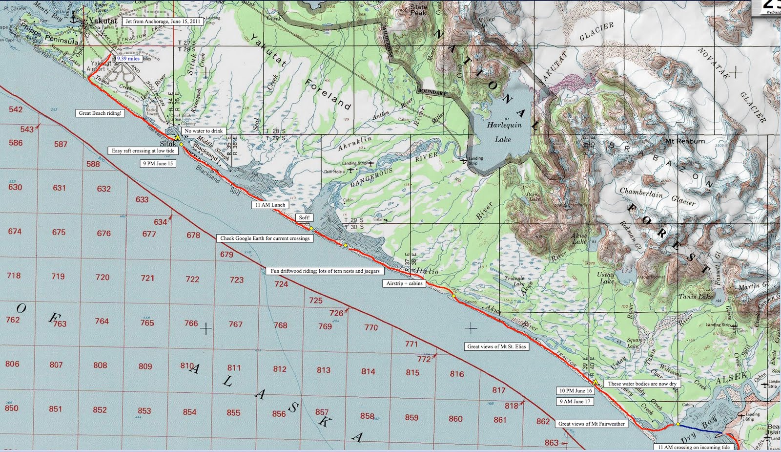
The first piece to just south of Dry Bay and north of the creek to the Grand Plateau Glacier looked like a long beach ride, punctuated with some boat crossings.
The second piece looked like about half pedaling, half pushing/carrying past glaciers and rocky points, ending down a bit south of Icy Point.
The third piece looked like pushing and paddling and Eric and I had different ideas about how to get over to Taylor Bay and MC and I different ideas about how to get to Icy Straight.
In general, the first half is dry.
For some dumb reason, neither of our first camps had drinking water.
The riding nears boring, but has some super cool driftwood and dune sections, and you'll want more than one gear. I had two and liked them both. The views of St Elias to the north and Fairweather to the south are great as long as the weather is nice. If the weather were bad, I am thinking you'd have headwinds and rain.
Dry Bay would be a great destination, if you wanted a short, less committing trip. Even as an out and back.
We got off the plane, packed our bikes, ate dinner and road to the beach, then pedaled to the Situk and camped. We boated across Situk River in the morning and made it to a couple hours shy of the Alsek. We crossed the Alsek as the tide came in and it was easy. We had coffee on the south bank. My point is the down an back could be, like, a three day trip.
The good beach continues down to the big boulders just before the northern outlet of the Grand Plateau Lake. Bear trails take you to the put-in at the lake where we found a note from Gordy and Thai. A funny note, about how silly we were to be riding bikes. It was on a Lindt chocolate wrapper. It was a delight.
We paddled the entire length of the lake -- first half in the twilight looking for a beach to camp on and finding one that was scary when a mini-tsunami followed a five minute calving event.
Doom slept on his boat that night.
The next day we paddled through amazing icebergs to the far end of the lake and then stumbled through bad Class IV brush with devils club, raspberry, nettles, and a giant curious bear that about got Doom pooping his pants when he bumped into it in the thick forest and it huffed at him.
Great beach riding starting on sand, increasing to gravel, then on to cobbles, and finally boulders leads to the spectacular Cape Fairweather. Here we alternated between shoving bikes down bear tubes on the wooded bluffs or stumbling and lifting loaded bikes over big boulders on the "beach".
Beyond we had great riding with remarkably constant beach backed by uniform forest. See Eric's clip
here. We pedaled onward at the amazing 6-7 mph (we had a tailwind -- generally we get 4-5 mph and sometimes only 3 mph in soft sand) and camped at pretty Eagle Creek, a few miles north of Lituya Bay.
Thankfully the notorious Lituya was easy and calm but I was nervous in my wee Scout and steep but short swells as we poked out into the bay. Near the far shore a wicked fast current whipped us out toward the mouth and I ferried like I was in a river to get out before going too far. More pushing on stubby bear trails past a fantastic sea lion haul out led to more riding. But again, the pushing was very bad before the good riding, very BAD (not like the photo below).

Unlike the
mountain hellbike trips of the nineties, this beach riding offers a less frequent split of riding vs pushing/carrying. Here on the Coast it's like, OK, two hours riding followed by two hours stumble-f*cking. Hellbiking was more like 5 minutes riding, 2 minutes pushing, 3 minutes riding, 7 minutes pushing. I exaggerate, but both seem to be about 50% non-riding to 50% riding but in different scales of time. On the coast it can be an entire day of riding, followed by an entire day of boating, followed by an entire day of pushing. This was new for me.
As we headed south the coast became rockier, not with boulders so much as with bedrock, rideable, challenging bedrock. There were some tough creek crossings, pinned between whitewater and surf, through rounded, polished boulders slick with green algae. Check the video below for some of that nasty action. Watching me with my bike over my head terrified the others. But watching them man-handle their frame-bag loaded bikes -- at one point Parsons just dropped his bike and watched it float nearly out to sea -- convinced me that over the head was far more stable.
We camped in view of La Perouse, an enormous surging glacier that had poked its brown head out into the Pacific, not fully, but enough to block the easy walk that Hig and Skurka had encountered. In fact, just a week earlier Thai and Gordy snuck by scrambling on boulders of ice, but we found the ice calving into surf, even at low tide.

Still, I pushed us into a dangerous situation, below calving ice and calf deep in surf that surged past ice blocks and boulders. When we turned a corner after an open area of easy walking, only to see massive cliffs shoved into surf, it was clearly time to retreat and sort out other options.
At one point on the way back a massive chunk of ice collapsed with in thirty feet of Doom, a terrifying moment that got us all running.
Dylan and I liked the idea of going over the glacier as opposed to Eric's idea of a surf launch. My boat was just too tiny to hop in easily with its fat bike cargo and narrow little slit through a mylar spray deck.
"I won't go first," was my cowardly response, "but I will go third." That way I'd see how likely I was to swim getting out past the breakers.
Following Eric's bold lead, we surf-launched our bikes. It was cool and felt clever, sneaky almost, like we were getting away with something risky as -- a mile or more from shore -- we paddled a few miles of the Pacific Ocean past a huge glacier.
Thankfully it was sunny and calm and warm and Doom took my front wheel and the only carnage was MC surf crashing and swimming at the landing. A six foot wave toppled him. The rest of us surfed in sweetly.
South we rode, sometimes pushed, crossing Little Bastard (my name) and Big Bastard Creeks (by raft -- also my name), two slimy, steep, cold streams draining Finger Glacier.
My favorite riding and where I found my two gears, one brake, and rack allowed me to ride more than the others, despite their massively higher skill level, was the bedrock spires and cobble beaches north of Icy Point. With no weight on my bars and a front brake and lower gear -- gosh it was sweet!
Written on my map these words capture some of the exuberance:
Best riding of the trip! Always challenging, always unexpected. Doom and I out front, swapping leads, grassy trails past rocky spires, weaving and dropping into chutes, all unexpected, unpredictable, unlikely, improbable and rideable! Awesome.
By the time we made our solstice camp past Icy Point our routine of twelve hour days followed by twelve hour camps set next to running fresh water was set. We got wood and set up 'mids and I heated water up in a big one gallon pot, but these are modern days and everyone ate food out of their own private plastic bag filled with water from their own private cook pot. At least we shared the fire and sometimes the tent, although I usually slept outside by the fire where the bugs were not bad. In the morning our group showed some unity when we all had coffee from the gallon pot. Yum.

Always the ballsy boater, Eric had us put in directly to Kaiknau Creek and float its splashy current into Palma Bay where he and Mike promptly paddled as far out to sea as they seemed to dare. Must have been an optical illusion for while I paddled straight for a point, Mike and Eric seemed to paddle further out to sea, presumably paddling for the same point.
Always the adventuring thrill seeker, Doom called up a whale that blew its spout on him in the deep bay. Startling as the bear!
We'd hoped to get out at Astrolabe Point for a break after La Palma, but the little lagoon was slimy with kelp and stinky with a dead harbor seal. Only Eric and Dylan climbed out. I peed and bobbed in my boat and we moved on, finding a cove on Sugarloaf's east side with driftwood, hot coffee, and a beach.
Paddling the calm inlets and bays was a treat and we were often visited by hummingbirds as we made our way toward Graves Bay. Near Libby island, Eric found a leak in his raft's valve (c. 2003 model, I think) and he patched it before shoving off again.
Our camp at Graves Harbor was even more idyllic than the last, made more interesting by a bear visit in the morning.
Eric had planned out a route that linked lakes and ponds, but these were mostly dry, muddy, rocky and brushy and it took us six hours to go three miles. See the map for a better way that requires a quick climb then a long paddle.
The brush was so bad that we blew up for a pond less than 100 yards long and THAT saved us time. On the far side of that pond we picked up a meadow, leading to a bear trail and another short lake paddle that took us to the newly grown brush beside the Brady Glacier.
Amazingly, isostatic rebound has changed the face of the water bodies marked on the USGS maps made in the 1950s. The islands shown on the eastern side of Taylor Bay are now peninsulas.
We made another dry camp and nobody but stubborn ole' MC wanted to bushwhack even a mile to Dundas Bay. So we democratically dragged our boats across mudflats and paddled Fern Harbor, then paddled out into North Indian Pass and Icy Straight.
These were idyllic waters for our boats, despite all the terrible stories and dire warnings Eric and Mike had heard from non-packrafters. Once again I recalled risk-averse Andy and Hig pointing out that Icy Straight is fast and safe and easy.
Like those saltwater explorers, we, too, made good time, pulling out for water to drink at the west side of Dundas and then paddling whitecaps over to the east side. We waited for the incoming tide (so much quicker!) at another creek opposite Lemesurier Island, hunkered in a short camp till morning, again waiting to ride the incoming tide, then cruising as fast as 5 mph without paddling as we took the tide into Glacier Bay and Gustavus, with whales all around.
An altercation with an uptight, quizzical park cop killed our buzz. Dylan got a $200 ticket for peeing into the water (we split it five ways) and threatened us with our un-permited trip.
Afterwords we pedaled into town feeling triumphant but let down by the Park Service again. What's wrong with them?
Gustavus seemed neat. We had pizza and beer then got on the 5:45 PM flight back to Anchorage, our buzz back and glowing.
"Best Trip In Alaska"?
For us it was during those ten days in June when it never rained and we saw the wildest coastline America has to offer.
All by fatbike and packraft, my favorite tools for exploration.




 Posts
Posts

