Alaska’s network of conservation areas may be unsurpassed in
the world. We need to keep it that way,
too. Write to our Senators and even that representative to say that we need to
keep Alaska’s wilderness and parklands wild, just in case our new president
tries something that spoils their wildness.
Of the 14 or so wilderness National Park units in Alaska,
two in the northwest part of the state are rarely visited by those from outside
the region: Kobuk Valley National Park and Bering Land Bridge National
Preserve.
This past summer as part of my quest to traverse all of the 14
wilderness NPS units in AK, I travelled to Kotzebue twice, once in early June
and again in mid-August to cross these remote parklands. They would be numbers
11 and 12 on my list begun in 1983 when Fairbanksan Jim Lokken and I crossed
the Kenai Fjords National Park from Seward to Homer by way of the Harding
Icefield.
Northwest Alaska is not generally as dramatic as, say, the
Alaska Range that so many peer at from a tour bus, the Wrangells that so many
“heart”, the glaciers of Southeast that so many cruise, or the Brooks Range that
so many fly over in small planes.
Northwest Alaska is big and empty. It’s the last frontier of
the Last Frontier and June is my favorite month to go, even if the bears are a
bit unruly then.
My own history with Northwest Alaska started in 1986 when I
paddled a Klepper kayak down a flooding Noatak River solo in 10 days of
September, completing a Brooks Range traverse from Kaktovik to Kotzebue. Leaving
from Pingo Lake in a howling wind and reaching Kotzebue with ice on my boat, I
shot a caribou on the way, floated it out and flew it home to Fairbanks.
My trip was inspired by Dick Griffith who’d traversed the
Range similarly but over two decades. In 1959 he walked mostly alone from
Kaktovik to Anaktuvuk. Then in 1977 he and his friend Bruce Stafford walked from
Anaktuvuk to the Noatak River where they then paddled Klepper kayaks to Kotzebue.
In 1976 Steve Hackett followed his bold, solo ascent of Mt. Igikpak, at 8510’
the highest Brooks Range peak west of the Pipeline, with a fast solo Klepper paddle
down the Noatak.
In 1987 I spent the summer in Nome with a mountain bike and
a Sherpa Packraft working for Alaska Gold on Dredge #6 by the Bering Sea, where Matt Desalernos got me a much-needed job. I had many adventures in and around Nome, some social some mountainous, all wild.
I made a
grand traverse of the Kigluaiks over a long weekend, climbing the spire on Mt. Osborne that to my eye looked tallest, walking to the Cobblestone River over Mosquito
Pass, then floating out the Sinuk River. Ian McCrae, who’s spent almost two
decades among the Kigluaiks has compiled that region’s mountaineering history in
a most entertaining fashion on his blog, Kigsblog (http://kigsblog-allapa.blogspot.com/)
Twenty years later in June 2006, again between the snow and
the mosquitoes, I returned to Kotzebue with Jason Geck and Ryan Jordan. We
three were intent on walking 625 miles without resupply or support – Wilderness
Classic style but without packrafts -- from Kivalina to the Haul Road through the
most remote spot in the USA. The spot is 119 miles from the nearest village or
road.
Unfortunately, after hyping up our trip on-line as the
“Arctic1000”, Ryan was forced to drop out with a twisted ankle a week into the
trip. Jason flew out from Anaktuvuk Pass, only 75 miles or so from the finish, to
his fiancé and as race organizer for the 2006 Wilderness Classic. I made it to
the Haul Road, 25 days and 625 miles from Kivalina.
On our long walk we saw over a dozen bears. Half of them
were far too curious about us. We took to hiding when we’d see bears because
we had only one can of bear spray and the bears took to running toward us from
up to a mile away when they’d see us. Unnerving.
Two Junes later, in 2008, my wife Peggy and I flew into the
same Utukok River airstrip Ryan Jordan had flown out from, but this time we had
iron and glass. Iron for bear protection and glass to watch animals and birds.
We packrafted north on the Utukok River to Archimedes Ridge, hiked west, then returned
south, up the Utukok River over Cairn Pass across the De Long Mountains to
packraft the Kugururok and Noatak Rivers to Noatak village (maps).
Again, the barren ground bears scared us on several
occasions. But on reflection that’s to be expected of hungry bears just
emerging from hibernation, in a hungry time before the caribou drop their
calves, in an otherwise hungry arctic landscape.
The scares comes from their “overbearing”
curiosity, when bears come at you as you simply walk, sit still, or boat. They
see you then pad over assertively to check you out and all the yelling, waving, clanking pans,
shooting-off guns or fire-crackers just are not enough to dissuade them.
These
are not Denali Park, Katmai, Kenai, or hunted bears. These are hungry bears
probing for weakness.
Another trip to Northwest Alaska was a weekend in November
2014, when Luc Mehl and I flew to Selawik and then Nordic ice-skated most of
the 100 miles to Kotzebue: down the Selawik River, over Selawik Lake (third
biggest in Alaska), across the Kobuk Delta and Kobuk Lake, walking the last 12
miles on a snow-machine trail at the tip of the Baldwin Peninsula into
Kotzebue.
This academic year, 2016-2017, is a sabbatical year for me,
which means I have time for creative activities, like exploring Northwest
Alaska’s parklands by foot and packraft.
I have been packrafting since 1983, writing the sport’s
first book, Packrafting! (buy it now as it's almost out of print and there'll be no second addition from me) Because
Alaska’s conservation lands are so extensive and wild, big rivers and steep
creeks without bridges or easy fords rule overland travel. It wasn’t until the
first durable packrafts made by Sherpa were available that summertime,
full-Park traverses were possible. Once we early adopters of packrafts used
them for crossing rivers we soon realized that we could float them, too.
Then with Thor Tingey’s urging of his mother Sheri Tingey in
2000, we started to get white-water worthy craft. Fifteen years later packrafts are good to-go-to on Class IV, steep creeks or big water, reasonably dry and surprisingly stable
and even reliably Eskimo rolled in combat situations.
But in Northwest Alaska’s parklands, Class II is about as
exciting as you can expect, but it's not really the whitewater that draws me there. It's the immense open landscape and biggest intact ecosystems in the USA.
Kobuk Valley National Park
On June 3, 2016 Brad Meiklejohn, professional conservationist, president
of the American Packrafting Association and architect of the Lower Eklutna Dam
Removal Project, and I flew with Alaska Airlines miles to Kotzebue. From Kotz
we flew with Eric Sieh of Arctic Backcountry Flying Service in a Cessna 206 to
a gravel bar at the junction of the Noatak and Sapun Creek, maybe an hour’s
flight. He was super helpful, providing us with fuel and, if we’d wanted, bear
spray. It’s also possible to buy those at the AC Store in Kotzebue.
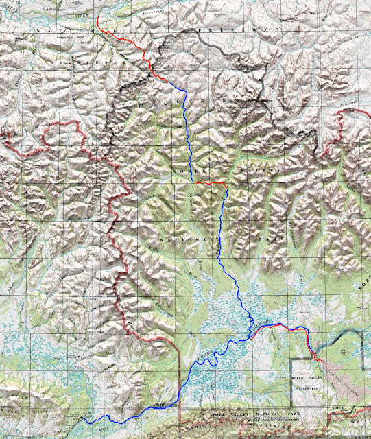
The weather was cold and windy when we landed. Huge wolf
and grizzly tracks punctuated the sand bar. We huddled in a grove of ten-foot tall
willows. Bushes were everywhere along the river and lower creeks and they were
flush with new growth from the new-normal of a warming Arctic.
The Baird Mountains separate the Kobuk and Noatak
watersheds. Kobuk Valley National Park preserves several entire watersheds
including the Salmon and Tutuksuk Rivers which are ideal wilderness packrafting
streams with nothing harder than easy Class II.
The Bairds are forested in the lowlands of their southern
slopes to an altitude of about a thousand feet. Above that is surprisingly brushy.
Willows choke creek bottoms, sunny slopes, elevated flats and seeps. Alders are
thick on low ridges and north slopes.
To break free of these bushes you need to
be at least 1,500 feet above sea level. The alders are not like those in Lake
Clark National Park, the Kenai, southside of the Alaska Range or Chugach Mountains,
or Southeast. On the north side of the Bairds they are relatively sparse, but
on the south side there are thickets. What's worst are the mixed alders and willows.

The Western Arctic caribou herd passes through these
mountains twice each year as they head north from their wintering grounds to
the calving areas in the Utukok Uplands. The caribou have left great trails
that go north-south, but moving from drainage to drainage, east-west, as is a
packrafter’s wont when river-skipping across landscapes, can be frustrating if
you haven’t yet polished your Zen of ‘schwack.
It took us a day to get from the Noatak to the Salmon River watershed
hiking along firm, level, and dry ridges that paralleled Sapun and Kanayat
Creeks. It was sunny but the wind blew strong and cold. Breeding surf-birds and
plovers squawked. When they flew the wind tossed them like feathered confetti. We
easily avoided tussocks by walking on lichen and Dryas covered ridge-lines. The tussocks were dry in early June with
dwarf birch shrubs growing on their tops.
As soon as we crossed into the Kobuk watershed brush was
more abundant. We linked ridgelines with caribou trails and made our way to an
un-named trib of the Salmon and put-in a couple miles above it. The creek was
shallow but we made it down without cutting our boats on its sharp schist, hoping
for more flow on the Salmon.


At first the Salmon was broad, flat, slow and shallow – a
disappointment. But as we made our way downstream, passing cottonwoods, and
then a few lonely spruce the river picked up flow and we made good time.
The mountains here are typical of Alaska’s Interior, even
though we were well above the Arctic Circle, what people who hail from Eagle
River or Anchorage might call “hills”. In my experience people from Anchorage
and Eagle River tend to yawn, loudly, at Interior topography. Like alcoholics
or junkies, Southcentral folks tend to juice up on bigger, sharper, icier
mountains and steeper, bigger, scarier whitewater. Those parts of Alaska in between
the Brooks and Alaska Ranges often bores them.
I can see their point (I’ve lived in Anchorage 25 years).
But as one who spent a youthful decade in Fairbanks, and who also spent
formative years in the Appalachians, I have a real soft-spot for those wild
Interior landscapes that look like New England may have before humans arrived.
It wasn’t cold on the Kobuk side but we still made spruce
fires on sand bars, heating tea and eating lunch after sitting in boats for a
couple hours at a stretch. The water was
amazingly clear. We watched huge grayling surface from deep blue pools to
snatch flies.
Somehow it was hot and yet without mosquitoes and after we’d
thrashed our way over to the Tutuksuk River, Brad bathed in its clear waters
while I napped in the sunshine wearing only shorts without head-net or bug dope:
Arctic idyllic.


The next day Brad, an inveterate birder, pointed out a
Siberian Tit, also known as Gray-headed Chickadee. This little bird is one that
life-listers long for, flying to Alaska to make river trips just to see it.
The Tutuksuk had some steep bluffs and even little rock
islands, its waters a bit more interesting than the Salmon’s. Tors crenellated
the ridgeline above until the ridges ran down to the Kobuk lowlands where the
Tut’s current slowed.
Just before reaching the lowlands we passed a grizzly on the
tall sandy bank. It immediately took an interest in us, padding along the bank
and tossing its head. The current was strong and with our paddles we easily
outpaced it, but Brad was surprised the bear followed us for 15 minutes of so,
popping in an out of view from the bankside willows as it hurried to keep up.
Brad has made annual trips to the Brooks Range for the last 30
years. Never had he seen a bear so relentlessly curious. But Brad’s trips generally
fall in August, when bears are well-fed and still feeding on berries, fish, and
a summer’s worth of kills and carrion.
Early June bears in the Arctic are hungry. There’re no
berries, no spawning fish, the winter’s carrion long since consumed by wolves
and foxes, the young and dumb prey not yet born.
As we wound our way through the loops of the lower Tutuksuk,
Brad used his Gaia ap on his phone to choose channels.
Reaching the Kobuk after midnight we floated downstream to
the first gravel bar and made camp. The mosquitoes had popped and we hoped that
the barren, wind-swept bar would keep them away. We made a driftwood fire and
went to bed.
Instead of floating on down to Kiana, Brad suggested we
follow the Kobuk 15 miles or so upstream to the Great Kobuk Sand Dunes.


The Kobuk was running strong and wide with spring run-off
and ferrying across took some muscle. Once across we walked along the sedge
covered banks often with flowering onion and chives poking through. The walking
was great and if we’d had fatbikes, or even 29-plus mountain bikes, we would
have made quick time.
The walking was so good we easily outpaced the bugs and
needed neither headnet nor bug-dope, except when stopped.
We stopped for several narrow but very deep side streams
that drained thick brush. We waded one that was belly-deep, jumped another that
was mud-slickened, and paddled a third. The fourth we ‘schwacked upstream to
step across.
Much of the way upstream we were reminded of how rich this
Interior country on the edge of the Arctic is. We saw geese and ducks and knew
that salmon and whitefish swam in this river. Most obvious were the spectacular
heads of bull caribou in the woods, on the banks and some still in the river.
These animals had been harvested by the Innupiaq who live in Noorvik, Kiana, Ambler,
Shungnak, and Kobuk.
Easy walking along the bank allowed easy thinking about how
rich and bountiful this region was. On the Noatak there is only one village. North
of the Noatak in Northwest Alaska the other Innupiaq villages are all coastal.
South of the Kobuk, along the Selawik River, like Noatak there is only one
village. South and west of Selawik most of the villages are coastal. Only along
the Kobuk do multiple villages stretch hundreds of miles upstream where people
have lived for a long time.
The modern locations of villages are historical, their
placement based on where trading posts, stores and schools were built. But to
persist, villages need access to resources, and only the Kobuk seems to have
enough year-round resources to supply a half dozen villages upstream for 200
miles.
As Brad and I walked farther we passed a recent fire scar.
Judging by the wilted leaves on the edge of the burn it looked to have happened
only weeks before. Even the tussocks had burned but were now sprouting new
growth out of their burned heads.
We walked through the burned forest. Across a tussock bog we
could see a small set of isolated dunes, a hint of the Great Kobuk Dunes. In the woods and perched on the river bank we
found multiple sites of old dwellings, rectangular pits now grown over by trees
with narrow entrances. We knew that upstream was Onion Portage, an ancient and
important pre-historic site dating back 10,000 years.
Along the Kobuk were wolf and bear tracks and leading to the
Kobuk Dunes were caribou highways. Like all game trails, and especially caribou
traces, they were easy to find but hard to hold as they would vanish when the
going got tough or easy.
I walked to the dunes from the river in about an hour,
following an obvious ridge above the Kobuk that is an old dune itself. I only
explored a small part of the Dunes after midnight, drawn to the vast expanse
that reached to the base of the Waring Mountains. It looked perfect for fatbike
exploration and I was tickled to hear later that photographer Carl Battreall
was there about the same time as we, pedaling the dunes.

Approaching the Kobuk Dunes reminded me of other dune areas
in Alaska, the Bremner Dunes on the Copper River and the Buffalo Dunes on the
Delta River. Spruce and soapberry bushes along with horsetail in the wetter
areas seemed to push into the dunes or maybe the dunes spilled into the
vegetation.
What was striking to me on the edge of the dunes were the
dryas meadows that looked like a sled dog-yard that had never been cleaned:
wolf turds everywhere. Just as I imagined the ancient Innupiaq discovering that
the Kobuk Valley is a protein-cornucopia with winter moose, spring and fall
caribou, summer fish and waterfowl, I imagined wolf packs waiting in the spruce
as caribou stepped off the dunes or followed the sandy creeks like Kavet Creek.

After spending the night, we blew up our rafts and floated 60
miles down the Kobuk to Kiana in a day and a half, catching the scheduled Bering
Air flight to Kotzebue.
Flying over the barren Baird Mountains, rounded and white,
looking very good for exploration by foot, but a bit dry for packrafting, I
thought I would very much like to return to the Kobuk region.

If I had a couple weeks, I’d fly to Kotz with a fatbike and
a packraft in May after the ice goes out and work my way upstream, riding the
Kobuk’s banks, the Dunes, and the dry vegetation laced with caribou trails
beyond them to Ambler. Then float the bike downstream on the high water of
early June.
But before I return to Kobuk Valley National Park, I told
myself, I have more parklands to cross: Katmai, Cape Krusenstern, and the next on
my list that June day was Bering Land Bridge National Preserve as part of a Seward Peninsula
traverse.
Bering Land Bridge National Preserve
In 1987 I spent a summer working in Nome for Alaska Gold.
With a mountain bike, a packraft and a full-time job I was limited to weekends
and after work adventures. But I had the USGS 1:250,000 Bendeleben and Solomon
quadrangles and on them I spied a route from Deering on Kotzebue Sound to the
end of the Council Road.
The route followed mining roads leading out of Deering, then
climbed to highlands peppered with evocative names like Crossfox Butte, Asses
Ears, Twincairn Cone. The route descended to Imuruk Lake, then crossed the lava
fields to Kuzitrin Lake, over the Bendeleben (pronounced “Ben-del-lay-ben”)
Mountains to Boston Creek and Fish River, then past Mt. Wick on what the map
marked a “winter trail” over the mountains to Council.

It took nearly 30 years, but it was a route I’d finally do
with Chris Flowers, pioneer of epic backcountry ski routes in the Chugach and
Kenai, the first to take a packraft from Girdwood to Knik through The Gorge,
and a pilot to boot.
Chris and I flew Alaska Airlines to Kotzebue on August 15 where we picked up stove fuel and
bear spray. But we couldn’t get either one on the Ravn Flight with us to
Deering. We waited in Deering for a cargo plane that we’d understood would
carry these hazardous goods, but when it arrived neither fuel nor
bear-deterrent was on board.
Deering is a neat village, with nice people, industrious and
helpful. Like Kivalina to the north and Shishmaref to the south, the village is
set between a lagoon and the sea and the sea is coming. Concrete blocks on the
beach and roadside were attempts to keep it at bay.

Waiting for the cargo flight we talked with locals who
showed photos on their phones of 12-foot tusks and 10-inch molars from
mastodons. Then we walked to the nearby 150 foot sea cliffs of Cape Deceipt, where
quiviut clung to the tundra grasses and cemetery fences, gyrfalcons soared
above puffins, murres, and kittiwakes, and a local guy walked his dog along the
beach.
In town people asked us what we were up to.
“Walking to Council,” we replied.
The next question was always the same. “Gotta gun?”
“No. We don’t even have bear spray. Couldn’t get it on the
flight.”
But we could have carried a firearm in an approved case. In
the future, I may bring a handgun and mail the case to the destination from the
start.
When it was apparent that our bear spray wasn’t coming and
we were set on leaving, one local woman had her teenage daughter give us a
thumb-sized can of rape-mace as protection.
We asked for a ride to the end of the mining road, but
no-one answered our call on the local CB even when we said we’d pay.
But once we were walking, several people seemed interested.
Some even came out in search of us. We went with a local woman married to a
First Nations man from Vancouver, BC. They had two ATVs. Chris got on one and I
got on the other.
They took us past several old gold dredges and we stopped to
explore the ghost town of Utica, its cute, boxy frame houses grayed by time and
overgrown in willows. They left us at the end of the road at Jack’s Camp, where
a miner had lived most of his life.

The miner took ill and left the camp and its collection of
interesting machinery, including an ancient tracked sno-go the size of a
Volkswagon Beetle and an ancient little Caterpillar tractor the size of an ATV.
We camped in a tin-shack on skids the locals used when hunting, berry-picking
and fishing.
On our second day we crossed the Inmachuk River with its
spawned out humpies and fresh bear tracks, following an old winter trail/ATV
track up a hill. The trail/ATV track leads 60 miles southwest to the Kougarok
Road. That route and the Kougarok Road on to Nome had been fatbiked by some
local Nome-ites and Fairbanksans a few years back.

I had on several occasions tried to get my beach fatbike
partners interested in a traverse of the Seward Peninsula. It was a hard sell.
Too often they would tell me that their Seward Peninsula friends said, No, not
worth it. But the Imnachuk-Kougarok Road route had never interested me. The
route I wanted to do – the one that Chris and I were finally doing but on foot
instead of bike -- crossed uplands and lava fields and packrafted down the Fish
River.
We left the trail/ATV track near where it enters the Bering
Land Bridge Preserve, enjoying firm, dry, and level footing from there all the
way to Asses Ears. From Asses Ears to Salix Bay, where’d we inflate and paddle
across Imuruk Lake stopping at the Gull Islands en route, we suffered tussocks for five solid miles. Sometimes
pint-sized, more often quart-sized or gallon-sized, but occasionally the size
of five gallon buckets, we stumbled stoically onward, looking for any edge
habitat as a respite, even if it meant wet feet or brush.

Since my first trips to the Brooks Range in the late 70s I
have noticed that climate change has been taming the tussocks. At first I
thought that I was just getting smarter, that I’d learned to avoid tussocks.
This perception, however is similar to that of some of my younger outdoor
partners who claim I am just getting older when I tell them the brush is worse
now than it was in the past.
But we have empirical proof in repeat photography that brush
is thickening in formerly tundra landscapes. I fully anticipate that the
vegetative-change scientists will soon publish the fact that tussocks are
drying up, too.
So, now I know where all the tussocks have gone: they’ve
gone to the flats north of Imuruk Lake.

By the time we reached the far shore of Imuruk Lake after a
seven mile paddle, we had a full on head wind and white-capped waves. Within an
hour of packing up our boats we’d discovered a lava flow complete with a
caribou trail and “inukshuks”, cairns and upended stones erected by Innupiaq
hunters and travelers. It was like a serpentine highway that lead us through
the tussock meadows south of the lake.
Walking the lava trail was both easy and exhilarating and we
made good time. Exhilarating because we were still a bit bruised from our tussock
stumbles and now we could look elsewhere besides our feet, such as into
collapsed lava tubes and at the textured, ropey surface of pahoehoe lava.

Finding water and wood for camp was less simple. Willows
were present, but few of the old growth individuals that have dead wood
standing at their centers were available. Most of the willow was young, recent
growth. And the porous lava fields didn’t hold water.
At every step since leaving Deering I thought about
fatbikes: how would they fare?

I have fatbiked on the Lost Coast from Yakutat to Gustavus
and Cordova across Icy Bay. And with mountain bikes a few of us travelled the length
of the Alaska Range from Canada to Lake Clark and across the Brooks Range from
Kaktovik to Arctic Village.
The lava fields here on the Seward Peninsula would be a
challenge, one best overcome with a lightly loaded bike to make pushes and
carries less onerous and the dynamic moves needed for rock-riding possible. But
every rider would also need a packraft to cross Imuruk Lake and to get down
Boston Creek and Fish River.

I’d go old-school hellbike, not new-school fatbike -- with a
26” mountain bike and the lightest and simplest packraft set-up available.
When the smooth pahoehoe headed west and our route to the
Bendlebens south we left the rideable lava and linked clinker-boulder fields
with pint-sized tussock fields. The boulder fields were amazingly stable and we
rock-hopped quickly and smoothly for hours.
My son had once worked on a biogeography and climate change
project in northwest Alaska, visiting Gates of the Arctic National Park, Cape
Krusenstern National Monument, Kobuk Valley National Park, and Bering Land
Bridge National Preserve. I’d asked him which place he liked best, as we shared
similar interests in landscapes, wildlife, and ecology.

He said Bering Land Bridge where he enjoyed a base camp at
Kusitrin Lake. There he saw wolverines and pre-historic sites, a beautiful lake
with a picturesque background. The principal investigator of the project had
found a lava cave there with an old pre-Columbian dog sled and spear.
But we’d taken a route that went west instead of east and
Kuzitrin would be a several-mile detour that I just couldn’t bring myself to
make, although now I wish that we had. The pull of floating down creeks and
rivers in a packraft was just too strong and my feet just too sore from lava,
sponga, boulders, and tussocks.
The pass into Boston Creek was gentle but the switch from
flat lava landscapes to Interior granite hills abrupt. Gone were willow
thickets on wetlands and instead were alder-covered hillslopes. We stayed high
and managed a brush-free descent to Boston Creek, a clear but shallow stream
splashing over rounded granite rocks.

We floated until midnight when the rain came and we made
camp. Bear and cub tracks were fresh. We’d already seen one bear cross the
creek downstream of us and were relieved to see it run off.
Over the two half-days and one full day that we paddled south
from the Bendelebens we would see 15 bears, more than either of us had seen in
such a short time outside of southwest Alaska.
The bears were drawn to the late season run of humpies that
lined the high-water mark like wax museum pieces of rotting gray flesh. We saw
a few cabins and were invited by into one for breakfast. But we were on a tight
schedule and had to turn the generous offer down as we paddled onward.

While Boston Creek was low volume it had some gradient. Fish
River was the reverse. We paddled in the rain that brought up the rivers,
getting chilled in the process. We hiked over the old winter trail to Council a
historic route used first by Natives, then as a telegraph line, and now as a
sometime ATV trail. It was beautiful ridge walk, even if mostly in mist and
clouds.
After eight days we reached Council. We were met at the
airstrip by two ATVs and three people who mistook us for two other adventurers
with packrafts who had left Deering on their own trip. We’d stopped at a
retired couples house for coffee and conversation. They called ahead on their
radio that we needed a ride. The case of mistaken identity was much to our
advantage and we were in Nome, sixty miles away, that night thanks to the
generosity and friendliness of those who call Council their vacation or
retirement home.

For me, Deering to Council satisfied a more personal quest.
I’d waited thirty years to make the traverse and was pleased by its variety of
people and cultures, its wildness and landscapes. To go from muskox and sea
cliffs outside an Innupiaq village to lava flows then brown bears and salmon
below Interior mountains with an active mining history makes the Seward
Peninsula the most interesting (to me) microcosm of Alaska.
Alaska blesses us Alaskans with natural beauty and a
wildness that gives us faith in the future. It’s important that we somehow
maintain that feeling for present and future generations.
Stamp Collecting
1983 Kenai Fjords – Seward to
Homer across the Harding Icefield
1986 Gates of the Arctic – Haul
Road to Pingo Lake over Doonerak and through the Arrigetch
1986 Noatak – Pingo Lake to
Kotzebue down the Noatak River
1986, 2013 Wrangell St. Elias
– Nabesna-McCarthy-Cordova through Chitistone and Tebay Lakes
1988 Yukon Charley – Boundary
to Circle down the Charley and Yukon Rivers
1989 Denali – Healy to Rainy
Pass (Skwentna) past Kantishna and through the Kitchatnas
1992 Klondike Gold Rush – Chilkoot
Trail
1994, 2015 Lake Clark –
Telaquana (Rainy Pass) to Pt. Alsworth to Iliamna
2011 Glacier Bay – Yakutat to
Gustavus across Alsek, Lituya Bay, Icy Straights, and Glacier Bay
2011 Aniakchak – Pt. Heiden
to Chignik over Vent Mountain, down Aniakchak River, along Pacific
2016 Kobuk Valley– Sapun
Creek to Kiana across Baird Mountains, down Salmon/Tutuksuk, Dunes
2016 Bering Land Bridge – Deering
to Council across Imruk Lake, Big Jim Lava Flow, Bendelebens
-->

