 “This place is boring. It’s all farmland! Too many sheep. It all looks the same. I like Australia better. And Alaska’s got better looking mountains.” So far, Peggy wasn’t too impressed with New Zealand.
We’d driven from Christchurch to the south end of the South Island via the coast, then back north along the edge of the Southern Alps by way of Queenstown, Lake Tekapo, and the sheep, cattle, and deer farm plains of Canterbury.
We skipped Mt. Cook as I’d been there a couple times before -- back in October 2005 as a tour guide for National Geographic Adventures and in October 2001 racing the Eco-Challenge Adventure Race with Team Earthlink.
I’d seen Mt Cook and crossed several of the mountain ranges east and south of it. Having seen NZ’s highest mountains in fine weather and foul, I had to agree with Peggy that a lot of New Zealand’s mountains looked like mediocre Alaskan ones.
But the West Coast ... now that lived up to Mark Twain’s observation: New Zealand was a place God made last, mixing the best bits of all the world in one place. Glaciers reaching almost to the sea; rocky coastlines; wind-sculpted, tropical-looking forests, small cow towns, and the most beautifully colored rivers in the world. We’d save the West Coast to share with daughter Jazz, due in from Portland on the 20th.
First we had to recover from the flu for three days in an Ashburton motel, watching TV, reading, and blogging. Then we had to make a six-night, 100 mile trip along and through the central Southern Alps.
The Southern Alps stretch the length of NZ’s South Island, crossed most famously at Arthur’s Pass, two hours west of Christchurch. My original plan was that Peggy and I’d walk and packraft from Arthur’s Pass to Mt Cook, a 10-day, maybe 150-mile trip.
After our flu and before Jazz’ arrival we were left with only nine days, days that had to include making food drops, getting there, and getting back. So we planned to make a six night, seven day trip to Lake Tekapo, if possible, and Erewhon Station, if necessary.
We left our town clothes and extra gear at Thistle Guesthouse, Church Corner, and started walking west out of town. We didn’t expect any rides in the neighborhoods but stuck out our thumbs occasionally anyway.
Surprisingly a middle aged South Australia couple, Helen and Phil, picked us up and drove us all the way to Bealey Bridge over the Waimakariri River in Arthur’s Pass National Park. Phil had met Helen when he and a friend had been hitchhiking on Kangaroo Island over 30 years ago. They’d only traveled outside of Australia twice: a long trip to Europe and this one to New Zealand.
“How do you get Peggy to walk?” Phil confided, “I can’t even get Helen out of the car.”
“She really likes to walk but hates to raft. I guess, it’s when i suggest we go rafting that she decides she’d rather go walking.”
They dropped us off at the bridge. It was raining, and now, Peggy, like Helen, wasn’t too keen on walking either.

We followed the Waimakariri river trail through mountain beech forests, very similar to the lenga forest we’d walked in Chilean Patagonia. They were mossy and green, dripping in the rain.
The trail left the forest and we left the trail. Unlike most of the trips during the last three decades before, this trip I’d let Peggy drift to the front and lead. That’s where the fun was, picking the way and making decisions about route choices, and probably why I hogged the lead.
Here she was excited to walk without bears or other threatening big animals. We’d had a couple bad bear scares in the northwest Arctic of Alaska last June, including one grizzly that insisted on coming toward us until we scared it away with a raised raft and inflated sleeping pad, making us look big. And another that found us in the brush, Peggy with her pants down peeing!
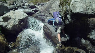
Peggy led us up Jordan Stream, a steep braided creek, clear and chill weaving from bank to bank over fist sized gray rocks.
She insisted on keeping her pants dry and rolled them up for every crossing, carefully choosing her steps to keep them dry. I just kept mine down, and typical-boy fashion, splashed across.
“When do you want to stop?”
“What time is it?”
“Six.”
“In about an hour?”
“OK. But the map shows that this creek’s pretty steep and rocky. We’ll have to keep our eyes open for a flat spot.”
Eventually the forest pinned the creek more closely and it bounced from bedrock corner to gravel bank. The gravel banks were steep, apparently from a mid-90s earthquake that dumped a lot of gravel in to the creek bed and that was being quickly cut by the fast moving stream.
Peggy delighted in her new trekking poles that gave her balance and confidence in the creek crossings. They were light and stiff and adjustable. She sheared one with me and we each handed ours to the other when we needed to hands to move past rock outcrops above deep pools.

“I really like being off-trail more than on-trail,” Peggy observed. “That Paine hike in Chile was scenic, but all that trail gets a little boring. It gives you too much time to think about how much your feet hurt and how heavy your pack is. “
“Yea, it’s a lot better to use your whole body,” I replied, jamming a carbon-fiber stick into the gravel for balance. “Plus, when you do get a trail it’s really nice after being off-trail.”
As it approached seven PM the creek was crowded in by canyon walls and we criss-crossed often. The boulders grew bigger and were surprisingly unstable for their size. At seven we made camp on a high gravel bar next to the forest’s edge. It was misting and fog clung to beech trees that themselves clung to steep mountain sides.
In the morning, Peggy was up first and announced that a big, dark green parrot had landed above our tent. I peered out the tent door to see a Kea, one of three parrot species in New Zealand.
Keas are a bit like ravens, in that their inquisitive and mischevious and sometimes destructive. Unlike their lowland relatives the kaka, the kea prefer mountains and don’t seem so noisy and social.
Eventually this one flew to the ground and inspected our camp, wary, but clearly waiting for a hand-out.

“I bet this guy gets fed,” Peggy suggested.
“Look, it’s got a leg band. Maybe it’s like a bad Park bear in the States, a trouble-maker that gets carted off to the wilder parts of a national park to stay out of trouble.”
As we made coffee and packed up the weather cleared and by the time we slid off the ten foot gravel embankment we’d camped on, the bright southern sun was shining.
In the southern hemisphere, this ozone hole business is real. Nearly everyday, a New Zealander dies of skin cancer. Just standing in the sun you can feel its burning heat, even when the air is cool. And there’s a certain quality to the light, a certain bright, but cool-white intensity, suggesting it’s on the short end of the spectrum, down there in the UV that is everywhere: on the beach, in the mountains, on the sidewalks.
I was thankful for my thick beard and long hair and the cool weather that kept our shirt sleeves long. Nevertheless we kept sticks of sunscreen handy, coating lips and exposed skin every hour or so.
Upwards Peggy took us, in and out of the ever-narrowing creek, over boulders and outcrops wet with water-spray, past waterfalls, and occasionally into the tussock grassland.
“There’re deer trails in here,” she announced, picking her way past the occasional pokey plant.
The creek steepened up all around as we broke free of the forest. The enclosing hillsides, too steep too walk, suggested we stay along the creek course but at some point we would have to climb out and into Jordan Saddle.
We came to an amazing waterfall that curtained off a boulder and followed a narrow deer trail between the enclosing cliffs. Above we could see that the creek curved to the southeast and we headed south, climbing a steep tussock hillside and into the long saddle.
Mountains rose all around us, some patched in snow, their bases cloaked in dark green mountain beech. Most were striped in gray scree. A cool breeze blew past us as we moved toward the south side of the pass.
Would it go? On the map it looked steep, save for a nose that looked forested between two drainages.
“I’m a little worried about the other side,” I said as we sidled up to the saddles crest. “It looks pretty steep on the map.”
Peggy pulled ahead as I shot some video behind us.
“Uh-oh! It’s not going to go!” She called out, holding her arms straight out supported by her poles, with her hips cocked, and a big smile on her face.


No comments:
Post a Comment